Environmental Informatics B.Sc.
Study Environmental Informatics (B.Sc.) – Computer Science, Sustainability, and Data for Environmental Solutions. The bachelor's degree program in Environmental Informatics combines Computer Science with current topics in the environment and sustainability. Students learn how to collect, analyze, model, and visualize environmental data – and how to use this data to develop digital solutions for climate protection, energy transition, mobility, and health. Whether it's climate models, digital city twins, or data-based environmental analyses, in environmental Computer Science you not only develop programs, but also deal with solutions to real social problems. The degree programme is unique in North Rhine-Westphalia and continues the successful geoinformatics degree programme at Bochum University of Applied Sciences – with an even more intensive focus on the environment, sustainability, and modern Computer Science.
At a glance
- Degree:
- Bachelor of Science
- Standard period of study:
- 7 or 9 (cooperative degree) semesters
- Programme start:
- Winter semester
- Campus:
- Central Campus Bochum
- Instruction language:
- German
- Credit points:
- 210 credit points
- Type of programme:
- Full-time and cooperative studies
- Type of admission (NC):
- Open admission (no NC)
Course content and focus areas
The bachelor's degree program in Environmental Informatics combines various disciplines, has a strong practical focus, and is clearly centered on Computer Science. It integrates content from Computer Science, geoinformatics, environmental sciences, and software engineering, and specifically prepares students for challenging tasks at the interface of IT, the environment, and society. You will acquire sound programming and data skills as well as a deep understanding of ecological, spatial, and sustainability-related issues.
During the course of your studies, you will learn to collect, analyze, model, and visually process environmental and geodata. This includes databases, web and application development, statistics, modeling, GIS technologies, and methods of environmental analysis. This is supplemented by the fundamentals of environmental sciences, such as climate, water, energy, and mobility, so that you can always evaluate technical solutions in a professional context.
There is a special focus on cross-semester projects: starting in the second semester, you will work continuously in interdisciplinary teams on practical issues – for example, in environmental monitoring, sensor data evaluation, or digital applications for municipalities, regions, and companies. The project structure is deliberately based on real work processes and promotes not only technical skills but also teamwork, project management, and communication.
Optionally, you can tailor your studies to your individual interests by specializing in geoinformatics. This specialization places a stronger focus on spatial data, GIS analysis, cartography, and geobased applications and is particularly suitable for students with previous training, for example, from geomatics or related training. This allows you to sharpen your profile and prepare yourself for specific professional fields.
During your studies, you will deal with topics such as:
Computer Science & Software Engineering
- Programming, Algorithms, and Data Structures
- Software Engineering and Sustainable Software Design (Green Coding)
- Web Technologies, IT Security
- Machine Learning, Artificial Intelligence, and Data Science
Environmental Informatics & Environmental Data
- Environmental and Geographic Information Systems (GIS)
- Collection, Management, and Analysis of Environmental Data
- Sensors, remote sensing, and Earth observation
- Modeling, simulation, and evaluation of environmental systems
Future topics & applications
- Digital twins and smart cities
- Climate resilience, energy transition, and transportation transition
- Environmental health, sustainability, and resource efficiency
- Life cycle assessment (LCA) and environmental assessment
Environmental informatics modules explained per semester
In the bachelor's program in Environmental Informatics, you will be introduced to the subject matter step by step. The program is structured in such a way that fundamentals, applications, and projects are meaningfully interlinked, allowing you to continuously deepen your knowledge.
In the first two semesters, you will lay the foundation for your studies. You will deal with mathematical fundamentals and receive a thorough introduction to Computer Science. At the same time, you will learn about key concepts in environmental informatics, for example in the System Earth module, which teaches ecological relationships and environmental systems. Initial programming modules ensure that all students—regardless of their prior knowledge—develop a common basis in Computer Science.
From the third semester onwards, the program becomes increasingly application-oriented. Building on the fundamentals, you will deepen your programming skills, learn about algorithms and data structures, and study environmental and geoinformation systems. Topics such as geodata management, remote sensing, and geovisualization show how environmental and geodata are collected, analyzed, and presented in a comprehensible way. At the same time, you will start with the first cross-semester environmental informatics projects, in which you will directly apply what you have learned in practice.
In the middle semesters, the focus is on modern methods and future topics. You will work with data science, machine learning, and artificial intelligence, model and simulate environmental systems, and deal with digital twins and smart cities. This is supplemented by modules such as sustainable software engineering and green coding, in which you will learn to develop software in a resource-efficient and responsible manner. Project work will continue to accompany you and will be based on real-world issues from practice and research.
From the fifth and sixth semesters onwards, you can increasingly tailor your studies to your individual focuses. In compulsory elective modules, you can set your own focuses, for example in the areas of environmental informatics, energy transition, transport transition, environment and health, or – optionally – with a specialization in geoinformatics. The project modules become more complex and prepare you specifically for professional practice.
In the seventh semester, the focus is on the transition to professional life. You complete a practical phase in which you apply your knowledge in a company, the administration, or a research institute. The bachelor`s thesis concludes the program and deals with a specific issue in the field of environmental informatics – often in close cooperation with a practical partner.
The result is a degree program that not only qualifies you professionally, but also enables you, step by step, to develop IT solutions for the environment, sustainability, and society.
The module manual will follow.
Hinweis Rahmenordnung
Beachten Sie bitte auch die Rahmenordnungen für die Studiengänge der Hochschule Bochum.
School leaving certificate
- Technical college entrance qualification (academic + practical) or university entrance qualification or comparable foreign qualification
or
- An equivalent qualification (study without university entrance qualification or technical college entrance qualification)
Pre-study internship
- No pre-study internship required
It is also possible to enter the program with a relevant professional qualification. For example, if you have completed training in a technical, IT, or environmental field, you may also be admitted to the program under certain conditions.
- e.g., geomatics engineer
- Environmental protection technician
- IT specialist
- Energy consultant
- Renewable energy specialist)
Special prior knowledge of Computer Science is helpful, but not a mandatory requirement. Motivation, interest in Computer Science and environmental issues, and a willingness to engage with mathematical and technical content are crucial.
International students
- A certificate recognized for study in Germany and proven language skills
What makes the Environmental Informatics degree programme special?
You will apply Computer Science to socially relevant issues. In the Bachelor's program in Environmental Informatics, you will program, analyze, and model data-based solutions for real-world challenges—from climate change and energy transition to sustainable mobility, environmental health, and livable cities.
You will receive solid training in Computer Science. You will learn programming, software engineering, data science, and artificial intelligence and systematically apply these skills in environmental and sustainability contexts. The degree programme is unique in North Rhine-Westphalia and combines Computer Science, environmental sciences, and geoinformatics into a clear, future-oriented profile.
A truly unique feature are the semester-long, practical projects: Starting in the second semester, you will work continuously in teams on real-world issues from research, administration, and practice. You will develop software, analyze real environmental data, build models, and experience how your work has an impact—for example, in environmental monitoring, urban and regional development, or digital twins.
The degree programme is deliberately interdisciplinary. Computer Science meets the environment, health, transportation, and energy. It is precisely this combination that makes alumni particularly sought after. As a logical further development of geoinformatics at Bochum University of Applied Sciences, you will also benefit from many years of experience, strong practical connections, and a modern didactic approach.
In short: if you enjoy programming, working with data, and want to put your computer science skills to good use, environmental informatics offers you exactly the right framework.
Career opportunities in environmental informatics – occupational fields & entry
Alumni/alumnae of environmental informatics are in high demand: they combine in-depth IT expertise with environmental and sustainability skills—a combination that is urgently sought after in many industries.
Career fields and activities
After completing your bachelor's degree (and, if applicable, a subsequent master's degree, e.g., in geoinformatics), you will work in areas such as:
- Engineering, planning, and IT offices
- at local, state, and federal authorities
- in environmental, energy, and transportation companies
- at research institutes and universities
- at start-ups in the fields of sustainability, smart cities, or data analysis
Typical job profiles include, for example:
- Development of environmental and geoinformation systems
- Analysis of large environmental and geodata sets
- Creation of digital twins for cities, regions, or infrastructures
- Modeling climate, energy, or transportation scenarios
- Software development for sustainable applications
- Consulting on data-based environmental and sustainability strategies
It is also possible to pursue further qualifications in a master's degree in geoinformatics or enter the civil service (e.g., with a focus on geoinformatics).


Get to know us at the information days!


Infotag Geodäsie (ausgebucht!!!!)
Infotag Geodäsie

Girls' Day - Messheld:in gesucht!
Girls' Day - Stadt-Designer:innen gesucht! - Ausgebucht


Katapult - Berufs- und Bildungsmesse

Full-time, cooperative with a company, or full-time plus?
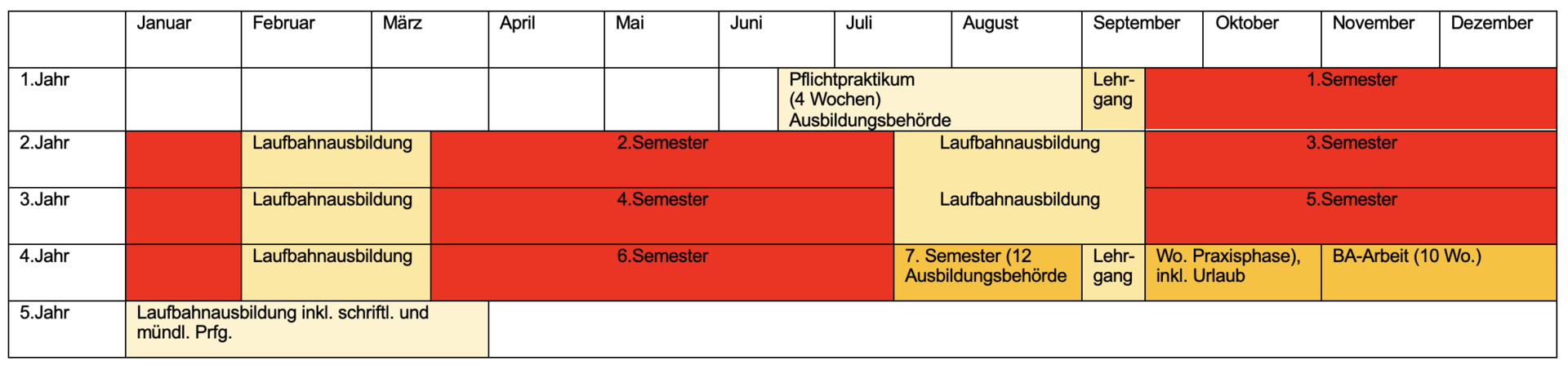
Would you like to concentrate fully on your studies, or do you value the opportunity to gain professional experiencealong the way and complete the preparatory service for a career in the civil service? Then you have two options:
Training plus study – not one after the other, but in parallel. The training-accompanying concept combines an apprenticeship in the field of surveying technology/IT and a Bachelor of Engineering degree. As long as training and study run in parallel (2 years or 4 semesters), students attend the university 2-3 days a week. The other days are spent at the company. After completing the vocational training, students continue full-time with the five-semester advanced studies program, which concludes with a bachelor's thesis. After only 9 semesters, you will have a vocational qualification and a bachelor's degree!
With the Full-Time Plus model, you work in several government agencies from the outset and earn money at the same time. This is a degree program with the option of a career in civil service. The model aims to teach practical professional skills and knowledge as admission requirements for entry into the first civil service position in career group 2, alongside the bachelor's degree in environmental informatics. You complete the necessary preparatory service during your dual study program. This saves you even more time.
Full-time Plus is offered exclusively with the geoinformatics study profile in the environmental informatics degree programme.
Studying at Campus Bochum
Modern, internationally orientated and surrounded by greenery - that's Bochum University of Applied Sciences. We have over 8,200 students studying at two different locations: the main campus in Bochum and the satellite campus in Heiligenhaus (CVH).
With our six faculties and more than 58 degree programmes, we attach great importance to encounters at eye level, supportive cooperation, personal support and strong practical relevance. There are numerous student working and research groups in which students from different degree programmes come together to learn. Topics such as Sustainable Bochum University, learning and working in projects (problem-based learning), Electric Mobility or climate change can be tackled here independently and closely supervised by lecturers. You can also obtain a doctoral degree here after completing a Master's degree.
The campus in Bochum is about 15 minutes by car or tram from the city centre, right next to the Ruhr University Bochum (RUB). All leisure activities for students there are also open to you: from university sports and the cultural café to the halls of residence. Bochum as a student city offers everything a student's heart desires: from art museum, theatre and concert hall to planetarium and mining museum to the party mile Bermudadreieck, city park and Kemnader See - take a look at Maps to see how green it is here!
Would you like to get to know the campus?
Take a look at our study orientation offers:
- in Bochum
We look forward to seeing you!
These degree programmes may also be of interest to you

Land Surveying (B.Eng.)
In the bachelor's degree program in Land Surveying, you will learn everything you need to know to collect, analyze, and present spatial data yourself.

Computer Science (B.Sc.)
Would you like to not only use digital devices and applications, but also help shape our digital future?

Civil Engineering (B.Sc.)
The field of civil engineering encompasses the entire built environment that surrounds us and its complex infrastructure.

Geoinformatics (M.Eng.)
After completing your bachelor's degree in environmental informatics, you can also study for a master's degree with us.
Note
The degree programme is currently still undergoing accreditation.